
Make a donation
Gear up for your next adventure:
As an Amazon Associate, this site earns from qualifying purchases at no extra cost to you.
La Purinière topographic map
Click on the map to display elevation.
Make a donation
Gear up for your next adventure:
As an Amazon Associate, this site earns from qualifying purchases at no extra cost to you.
About this map
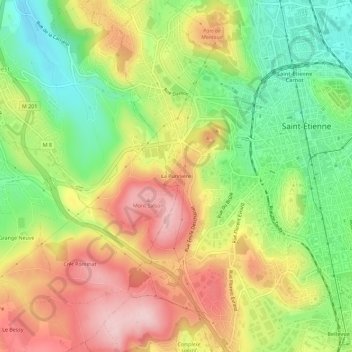
Name: La Purinière topographic map, elevation, terrain.
Average elevation: 583 m
Minimum elevation: 469 m
Maximum elevation: 705 m
Make a donation
Gear up for your next adventure:
As an Amazon Associate, this site earns from qualifying purchases at no extra cost to you.
Other topographic maps
Click on a map to view its topography, its elevation and its terrain.
Rochetaillée
France > Auvergne-Rhône-Alpes > Loire > Saint-Étienne
Le village de Rochetaillée (point culminant de Saint-Étienne) est perché entre 775 et 1 117 mètres d'altitude, dans le massif du Pilat. Au recensement de novembre 1999, sa population était de 757 habitants (les Rupisciciens). Rochetaillée dépend administrativement de Saint-Étienne, faisant partie de…
Average elevation: 917 m
Make a donation
Gear up for your next adventure:
As an Amazon Associate, this site earns from qualifying purchases at no extra cost to you.
Château de la Perrotière
France > Auvergne-Rhône-Alpes > Loire > Saint-Étienne
Average elevation: 613 m
Make a donation
Gear up for your next adventure:
As an Amazon Associate, this site earns from qualifying purchases at no extra cost to you.