
Make a donation
Gear up for your next adventure:
As an Amazon Associate, this site earns from qualifying purchases at no extra cost to you.
Wuling topographic map
Click on the map to display elevation.
Make a donation
Gear up for your next adventure:
As an Amazon Associate, this site earns from qualifying purchases at no extra cost to you.
Wuling
Wuling (Chinese: 武嶺; pinyin: Wǔlǐng, el 3275 m), formerly known as Sakuma Pass (佐久間峠, Sakuma-tōge), is a mountain pass located in Ren'ai, Nantou, Taiwan, transversing the Central Mountain Range near the peak of Hehuanshan within Taroko National Park. It is the highest paved road in elevation in Taiwan.
Make a donation
Gear up for your next adventure:
As an Amazon Associate, this site earns from qualifying purchases at no extra cost to you.
About this map
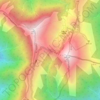
Name: Wuling topographic map, elevation, terrain.
Average elevation: 3,079 m
Minimum elevation: 2,618 m
Maximum elevation: 3,405 m
Make a donation
Gear up for your next adventure:
As an Amazon Associate, this site earns from qualifying purchases at no extra cost to you.