
Make a donation
Gear up for your next adventure:
As an Amazon Associate, this site earns from qualifying purchases at no extra cost to you.
Rayton topographic map
Click on the map to display elevation.
Make a donation
Gear up for your next adventure:
As an Amazon Associate, this site earns from qualifying purchases at no extra cost to you.
About this map
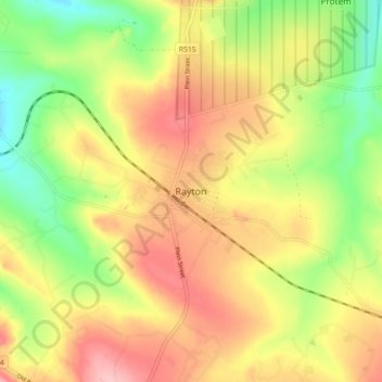
Name: Rayton topographic map, elevation, terrain.
Average elevation: 1,459 m
Minimum elevation: 1,383 m
Maximum elevation: 1,531 m
Make a donation
Gear up for your next adventure:
As an Amazon Associate, this site earns from qualifying purchases at no extra cost to you.
Other topographic maps
Click on a map to view its topography, its elevation and its terrain.
Rietvlei Dam
South Africa > Gauteng > City of Tshwane Metropolitan Municipality > Doornkloof East
Average elevation: 1,489 m
Bronkhorstspruit Dam
South Africa > Gauteng > City of Tshwane Metropolitan Municipality
Average elevation: 1,462 m
Bronkhorstspruit
South Africa > Gauteng > City of Tshwane Metropolitan Municipality
Average elevation: 1,502 m
Make a donation
Gear up for your next adventure:
As an Amazon Associate, this site earns from qualifying purchases at no extra cost to you.
Centurion Lake
South Africa > Gauteng > City of Tshwane Metropolitan Municipality > Centurion
Average elevation: 1,440 m
Roodeplaat Dam
South Africa > Gauteng > City of Tshwane Metropolitan Municipality
Average elevation: 1,214 m
Tshwane Ward 105
South Africa > Gauteng > City of Tshwane Metropolitan Municipality
Average elevation: 1,442 m
Morula View Park
South Africa > Gauteng > City of Tshwane Metropolitan Municipality
Average elevation: 1,201 m
Make a donation
Gear up for your next adventure:
As an Amazon Associate, this site earns from qualifying purchases at no extra cost to you.
Wierda Glen
South Africa > Gauteng > City of Tshwane Metropolitan Municipality > Simarlo AH
Average elevation: 1,479 m
Danville
South Africa > Gauteng > City of Tshwane Metropolitan Municipality > Pretoria
Average elevation: 1,351 m
Roodeplaat Dam Nature Reserve
South Africa > Gauteng > City of Tshwane Metropolitan Municipality
Average elevation: 1,240 m
Roodeplaat Dam
South Africa > Gauteng > City of Tshwane Metropolitan Municipality
Average elevation: 1,214 m
Make a donation
Gear up for your next adventure:
As an Amazon Associate, this site earns from qualifying purchases at no extra cost to you.
Tshwane Ward 65
South Africa > Gauteng > City of Tshwane Metropolitan Municipality
Average elevation: 1,487 m
Tshwane Ward 91
South Africa > Gauteng > City of Tshwane Metropolitan Municipality
Average elevation: 1,513 m
Tshwane Ward 100
South Africa > Gauteng > City of Tshwane Metropolitan Municipality
Average elevation: 1,408 m
Bronkhorstspruit Dam
South Africa > Gauteng > City of Tshwane Metropolitan Municipality
Average elevation: 1,462 m
Make a donation
Gear up for your next adventure:
As an Amazon Associate, this site earns from qualifying purchases at no extra cost to you.
Tshwane Ward 30
South Africa > Gauteng > City of Tshwane Metropolitan Municipality
Average elevation: 1,206 m
Himalya Street Park
South Africa > Gauteng > City of Tshwane Metropolitan Municipality > Pretoria
Average elevation: 1,456 m
Tshwane Ward 54
South Africa > Gauteng > City of Tshwane Metropolitan Municipality
Average elevation: 1,287 m
Tshwane Ward 53
South Africa > Gauteng > City of Tshwane Metropolitan Municipality
Average elevation: 1,312 m
Make a donation
Gear up for your next adventure:
As an Amazon Associate, this site earns from qualifying purchases at no extra cost to you.