Geolocate

Dongara topographic map

Click on the map to display elevation.

About this map

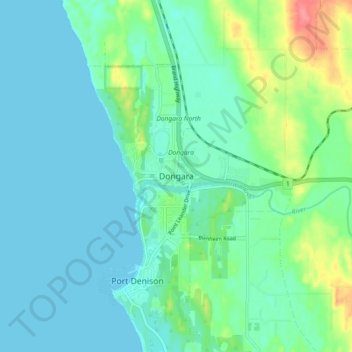
Name: Dongara topographic map, elevation, terrain.

Location: Dongara, Shire Of Irwin, Western Australia, 6525, Australia (-29.29081 114.89140 -29.21081 114.97140)

Average elevation: 16 m

Minimum elevation: 0 m

Maximum elevation: 73 m

Gear up for your next adventure:

🥾Hiking Boots - Sturdy boots providing ankle support and traction on rugged trails
🧣Merino Neck Gaiter - Protects against wind, sun, and cold at high altitudes
👟Sport Hiking Sandals - Breathable footwear for water crossings and camp rest
💡LED Headlamp - Hands-free illumination for night hiking and camping
Family Camping Tent - Spacious tent suitable for family camping trips

As an Amazon Associate, this site earns from qualifying purchases at no extra cost to you.