
Make a donation
Gear up for your next adventure:
As an Amazon Associate, this site earns from qualifying purchases at no extra cost to you.
Santa Rita topographic map
Click on the map to display elevation.
Make a donation
Gear up for your next adventure:
As an Amazon Associate, this site earns from qualifying purchases at no extra cost to you.
Santa Rita
La ciudad de Santa Rita se encuentra dentro de la Unidad fisiográfica "depresión del lago de Valencia" y específicamente en su planicie central. Su relieve es plano con ligera pendiente hacia el suroeste. La elevación es de unos 428 m s. n. m.
Make a donation
Gear up for your next adventure:
As an Amazon Associate, this site earns from qualifying purchases at no extra cost to you.
About this map
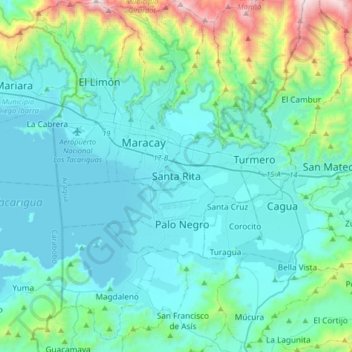
Name: Santa Rita topographic map, elevation, terrain.
Average elevation: 662 m
Minimum elevation: 401 m
Maximum elevation: 2,209 m
Make a donation
Gear up for your next adventure:
As an Amazon Associate, this site earns from qualifying purchases at no extra cost to you.