Geolocate

Haraluru topographic map

Click on the map to display elevation.

About this map

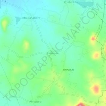
Name: Haraluru topographic map, elevation, terrain.

Location: Haraluru, Tumkur taluk, Tumakuru District, Karnataka, India (13.23249 77.14693 13.27249 77.18693)

Average elevation: 864 m

Minimum elevation: 827 m

Maximum elevation: 960 m

Gear up for your next adventure:

Camping Groundsheet - Protect your tent from moisture and dirt
🦟Insect Repellent - Keep mosquitoes and black flies away in wooded areas
🧥Softshell Hiking Jacket - The perfect balance of wind protection and breathability
Lightweight Camping Tent - Portable shelter optimized for Canadian backcountry camping
🧥Thermal Fleece Jacket - Versatile insulation for changing mountain temperatures

As an Amazon Associate, this site earns from qualifying purchases at no extra cost to you.