
Make a donation
Gear up for your next adventure:
As an Amazon Associate, this site earns from qualifying purchases at no extra cost to you.
Buzeins topographic map
Click on the map to display elevation.
Make a donation
Gear up for your next adventure:
As an Amazon Associate, this site earns from qualifying purchases at no extra cost to you.
Buzeins
Située à 748 mètres d'altitude, l'Aveyron, le ruisseau de Cuge, le ruisseau de Malrieu sont les principaux cours d'eau qui traversent la commune de Buzeins. C'est une commune du parc naturel régional des Grands Causses.
Make a donation
Gear up for your next adventure:
As an Amazon Associate, this site earns from qualifying purchases at no extra cost to you.
About this map
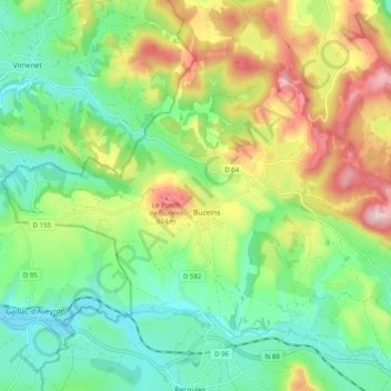
Name: Buzeins topographic map, elevation, terrain.
Average elevation: 710 m
Minimum elevation: 605 m
Maximum elevation: 893 m
Make a donation
Gear up for your next adventure:
As an Amazon Associate, this site earns from qualifying purchases at no extra cost to you.
Other topographic maps
Click on a map to view its topography, its elevation and its terrain.