
El Carmen topographic map
Interactive map
Click on the map to display elevation.
About this map
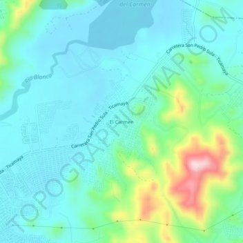
Name: El Carmen topographic map, elevation, terrain.
Location: El Carmen, San Pedro Sula, Cortés, 21101, Honduras (15.50708 -87.98306 15.54708 -87.94306)
Average elevation: 96 m
Minimum elevation: 38 m
Maximum elevation: 312 m
Other topographic maps
Click on a map to view its topography, its elevation and its terrain.
Cofradía
Honduras > Cortés > San Pedro Sula
Cofradía, San Pedro Sula, Cortés, Honduras
Average elevation: 159 m
Parque Universitario UNAH-VS
Honduras > Cortés > San Pedro Sula
Parque Universitario UNAH-VS, San Pedro Sula, Cortés, Honduras
Average elevation: 121 m
Cordillera El Merendon
Honduras > Cortés > San Pedro Sula
Cordillera El Merendon, San Pedro Sula, Cortés, Honduras
Average elevation: 558 m