
Thank you for supporting this site ❤️
Make a donation
Make a donation
Gear up for your next adventure:
As an Amazon Associate, this site earns from qualifying purchases at no extra cost to you.
Waldenberg topographic map
Click on the map to display elevation.
Thank you for supporting this site ❤️
Make a donation
Make a donation
Gear up for your next adventure:
As an Amazon Associate, this site earns from qualifying purchases at no extra cost to you.
About this map
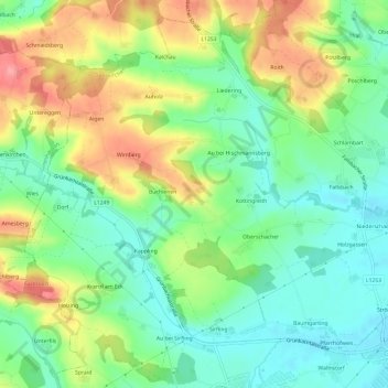
Name: Waldenberg topographic map, elevation, terrain.
Location: Waldenberg, Gunskirchen, Bezirk Wels-Land, 4623, Austria (48.12986 13.89014 48.16986 13.93014)
Average elevation: 384 m
Minimum elevation: 344 m
Maximum elevation: 448 m
Thank you for supporting this site ❤️
Make a donation
Make a donation
Gear up for your next adventure:
As an Amazon Associate, this site earns from qualifying purchases at no extra cost to you.