
Make a donation
Gear up for your next adventure:
As an Amazon Associate, this site earns from qualifying purchases at no extra cost to you.
Rocky Butte topographic map
Click on the map to display elevation.
Make a donation
Gear up for your next adventure:
As an Amazon Associate, this site earns from qualifying purchases at no extra cost to you.
About this map
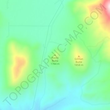
Name: Rocky Butte topographic map, elevation, terrain.
Location: Rocky Butte, Blaine County, Idaho, United States (43.45569 -114.37621 43.45579 -114.37611)
Average elevation: 1,727 m
Minimum elevation: 1,616 m
Maximum elevation: 2,018 m
Make a donation
Gear up for your next adventure:
As an Amazon Associate, this site earns from qualifying purchases at no extra cost to you.
Other topographic maps
Click on a map to view its topography, its elevation and its terrain.
Bellevue
United States > Idaho > Blaine County
Bellevue is located at 43°27′54″N 114°15′24″W / 43.46500°N 114.25667°W / 43.46500; -114.25667 (43.465019, -114.256755), at an elevation of 5,170 feet (1,576 m) above sea level.
Average elevation: 1,667 m
Make a donation
Gear up for your next adventure:
As an Amazon Associate, this site earns from qualifying purchases at no extra cost to you.