
Thank you for supporting this site ❤️
Make a donation
Make a donation
Gear up for your next adventure:
As an Amazon Associate, this site earns from qualifying purchases at no extra cost to you.
Kakolu topographic map
Click on the map to display elevation.
Thank you for supporting this site ❤️
Make a donation
Make a donation
Gear up for your next adventure:
As an Amazon Associate, this site earns from qualifying purchases at no extra cost to you.
About this map
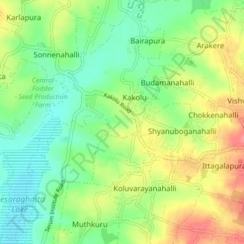
Name: Kakolu topographic map, elevation, terrain.
Location: Kakolu, Yelahanka taluku, Bengaluru Urban, Karnataka, India (13.15183 77.48991 13.21112 77.52396)
Average elevation: 880 m
Minimum elevation: 852 m
Maximum elevation: 921 m
Thank you for supporting this site ❤️
Make a donation
Make a donation
Gear up for your next adventure:
As an Amazon Associate, this site earns from qualifying purchases at no extra cost to you.