Geolocate

Corales topographic map

Interactive map

Click on the map to display elevation.

About this map

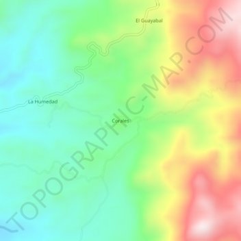
Name: Corales topographic map, elevation, terrain.

Location: Corales, Técpan de Galeana, Guerrero, Mexico (17.36278 -100.80417 17.40278 -100.76417)

Average elevation: 491 m

Minimum elevation: 264 m

Maximum elevation: 870 m

Other topographic maps

Click on a map to view its topography, its elevation and its terrain.

Francisco Ruiz Massieu

Mexico > Guerrero > Técpan de Galeana > San Luis San Pedro

Francisco Ruiz Massieu, San Luis San Pedro, Técpan de Galeana, Guerrero, Mexico

Average elevation: 75 m