Geolocate

Taizhou topographic map

Click on the map to display elevation.

About this map
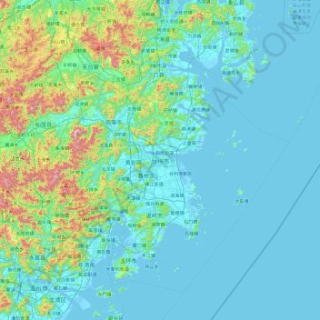
Name: Taizhou topographic map, elevation, terrain.

Location: Taizhou, Zhejiang, China (27.97163 120.28544 29.34700 122.17828)

Average elevation: 141 m

Minimum elevation: -2 m

Maximum elevation: 1,318 m

Other topographic maps

Click on a map to view its topography, its elevation and its terrain.
Lion mountain

China > Zhejiang > Hangzhou City

Average elevation: 15 m

甘山

China > Zhejiang > Chun'an County

Average elevation: 250 m

Gear up for your next adventure:

🥾Waterproof Hiking Boots - Boots keeping your feet dry in wet conditions
🦌Outdoor Trail Camera - Monitor wildlife activity near your favorite spots
🕶️Polarized Sunglasses - Reduces glare from snow and water at high elevations
🧢Sun Hat - Wide-brim hat for sun protection
🧶550 Survival Paracord - Versatile utility cord for emergency repairs and rigging

As an Amazon Associate, this site earns from qualifying purchases at no extra cost to you.