
Make a donation
Gear up for your next adventure:
As an Amazon Associate, this site earns from qualifying purchases at no extra cost to you.
Malvern topographic map
Click on the map to display elevation.
Make a donation
Gear up for your next adventure:
As an Amazon Associate, this site earns from qualifying purchases at no extra cost to you.
Malvern
Malvern lies in the Lower Severn/Avon plain affording it a degree of shelter caused by virtue of its nestling in between the Cotswold hills to the east, the Welsh Hills and Mountains to the west, and Birmingham plateau to the north. Although as with all the British Isles it has a maritime climate, the local topography means summer warmth can become emphasised by a slight foehn effect off the surrounding hills. The record maximum stands at 35.8c(96.4f) set in August 1990. Typically 17.3 days of the year will reach 25.1c(77.2f) or higher and the annual warmest day should reach 29.8c(85.6f) according to the 1971–00 observing period.
Make a donation
Gear up for your next adventure:
As an Amazon Associate, this site earns from qualifying purchases at no extra cost to you.
About this map
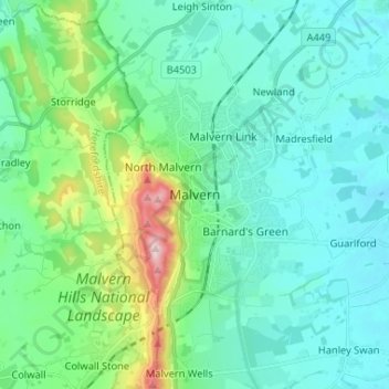
Name: Malvern topographic map, elevation, terrain.
Average elevation: 95 m
Minimum elevation: 19 m
Maximum elevation: 423 m
Make a donation
Gear up for your next adventure:
As an Amazon Associate, this site earns from qualifying purchases at no extra cost to you.