Geolocate

Leonberg topographic map

Click on the map to display elevation.

About this map

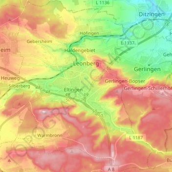
Name: Leonberg topographic map, elevation, terrain.

Location: Leonberg, Landkreis Böblingen, Baden-Württemberg, 71229, Germany (48.74587 8.95713 48.83350 9.06881)

Average elevation: 413 m

Minimum elevation: 293 m

Maximum elevation: 521 m

Gear up for your next adventure:

🥾Trail Hiking Shoes - Durable shoes designed for rugged trails
🚲Heavy Duty Bike Lock - Secure your bike at the trailhead or during stops
💡LED Headlamp - Hands-free illumination for night hiking and camping
🧦Merino Wool Socks - Moisture-wicking comfort for long-distance hiking
🔥Emergency Fire Starter - Reliable ignition source for all weather conditions

As an Amazon Associate, this site earns from qualifying purchases at no extra cost to you.