
Gaithersburg topographic map
Click on the map to display elevation.
About this map
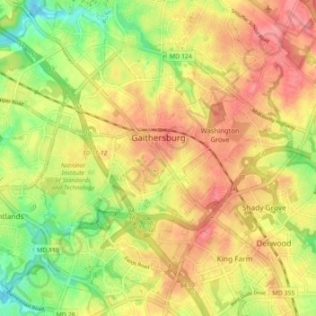
Name: Gaithersburg topographic map, elevation, terrain.
Location: Gaithersburg, Montgomery County, Maryland, United States (39.10275 -77.25827 39.16831 -77.17118)
Average elevation: 137 m
Minimum elevation: 93 m
Maximum elevation: 171 m
Other topographic maps
Click on a map to view its topography, its elevation and its terrain.
Lock 22: Pennyfield Lock
United States > Maryland > Montgomery County > Travilah
Ground was broken for construction of the C&O Canal on July 4, 1828. One of the early plans was for the canal to be a way to connect the Chesapeake Bay with the Ohio River. The canal has several types of locks, including 74 lift locks necessary to handle a 608-foot (185 m) difference in elevation between the…
Average elevation: 73 m
Sandy Spring Meadow
United States > Maryland > Montgomery County > Sandy Spring
Average elevation: 136 m
Seneca Park
United States > Maryland > Montgomery County > Montgomery Village
Average elevation: 124 m
Burnt Mills Village
United States > Maryland > Montgomery County > Burnt Mills
Average elevation: 104 m