
Thank you for supporting this site ❤️
Make a donation
Make a donation
Gear up for your next adventure:
As an Amazon Associate, this site earns from qualifying purchases at no extra cost to you.
Múceres topographic map
Click on the map to display elevation.
Thank you for supporting this site ❤️
Make a donation
Make a donation
Gear up for your next adventure:
As an Amazon Associate, this site earns from qualifying purchases at no extra cost to you.
About this map
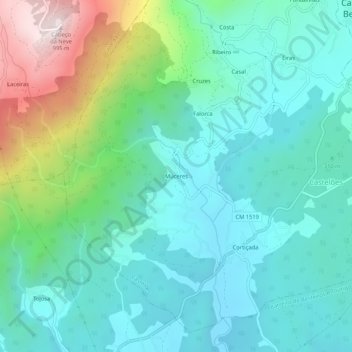
Name: Múceres topographic map, elevation, terrain.
Location: Múceres, Castelões, Tondela, Viseu, 3465-127, Portugal (40.51639 -8.18185 40.55639 -8.14185)
Average elevation: 376 m
Minimum elevation: 186 m
Maximum elevation: 987 m
Thank you for supporting this site ❤️
Make a donation
Make a donation
Gear up for your next adventure:
As an Amazon Associate, this site earns from qualifying purchases at no extra cost to you.