
Make a donation
Gear up for your next adventure:
As an Amazon Associate, this site earns from qualifying purchases at no extra cost to you.
Frankenthal (Pfalz) topographic map
Click on the map to display elevation.
Make a donation
Gear up for your next adventure:
As an Amazon Associate, this site earns from qualifying purchases at no extra cost to you.
Frankenthal (Pfalz)
Der Jahresniederschlag beträgt 528 mm. Dies ist ein relativ niedriger Wert, der im unteren Zehntel der in Deutschland erfassten Werte liegt; nur an 6 Prozent der Messstationen des Deutschen Wetterdienstes werden noch geringere Niederschläge registriert. Der trockenste Monat ist der Februar, die meisten Niederschläge fallen im Juni, nämlich 2,4-mal mehr als im Februar. Die Niederschläge variieren stark, lediglich 28 Prozent der Messstationen verzeichnen noch höhere jahreszeitliche Schwankungen.
Make a donation
Gear up for your next adventure:
As an Amazon Associate, this site earns from qualifying purchases at no extra cost to you.
About this map
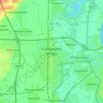
Name: Frankenthal (Pfalz) topographic map, elevation, terrain.
Location: Frankenthal (Pfalz), Rheinland-Pfalz, 67227, Deutschland (49.50458 8.31401 49.58458 8.39401)
Average elevation: 95 m
Minimum elevation: 85 m
Maximum elevation: 120 m
Make a donation
Gear up for your next adventure:
As an Amazon Associate, this site earns from qualifying purchases at no extra cost to you.
Other topographic maps
Click on a map to view its topography, its elevation and its terrain.