
Make a donation
Gear up for your next adventure:
As an Amazon Associate, this site earns from qualifying purchases at no extra cost to you.
Puerto La Cruz topographic map
Click on the map to display elevation.
Make a donation
Gear up for your next adventure:
As an Amazon Associate, this site earns from qualifying purchases at no extra cost to you.
Puerto La Cruz
The city of Puerto La Cruz is located on the southern shore of the Caribbean. The elevation of the city varies between 767 and 64 metres (2,516 and 210 ft). The city position is at Latitude 10° 13' N and Longitude 64° 37' W. Typical temperatures vary between 25–28 °C (77–82 °F). Borders are represented by Mochima National Park, the North Eastern region, and the Coastal Mountains.
Make a donation
Gear up for your next adventure:
As an Amazon Associate, this site earns from qualifying purchases at no extra cost to you.
About this map
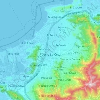
Name: Puerto La Cruz topographic map, elevation, terrain.
Average elevation: 89 m
Minimum elevation: -1 m
Maximum elevation: 539 m
Make a donation
Gear up for your next adventure:
As an Amazon Associate, this site earns from qualifying purchases at no extra cost to you.