
Fürth topographic map
Click on the map to display elevation.
Fürth
Der historische Stadtkern befindet sich östlich und südlich der Flüsse Rednitz und Pegnitz, die nordwestlich der Altstadt zur Regnitz zusammenfließen. Westlich der Stadt, jenseits von Südwesttangente und Main-Donau-Kanal, steigt der Fürther Stadtwald an. Östlich der Stadt liegt in etwa gleicher Höhe die Stadt Nürnberg. Nördlich dehnt sich das fruchtbare, teilweise zum Stadtgebiet gehörende Knoblauchsland aus. Südlich der Stadt liegt ein Mischgebiet aus breiten Autostraßen, Kanal und Flussauen.
About this map
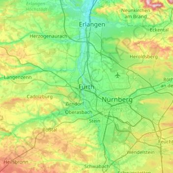
Name: Fürth topographic map, elevation, terrain.
Location: Fürth, Bayern, 90762, Deutschland (49.31725 10.82936 49.63725 11.14936)
Average elevation: 343 m
Minimum elevation: 266 m
Maximum elevation: 543 m
Other topographic maps
Click on a map to view its topography, its elevation and its terrain.