Geolocate

Curpacancha topographic map

Click on the map to display elevation.

About this map

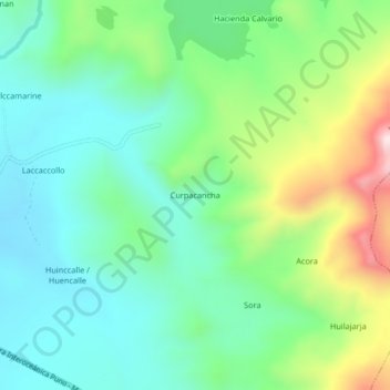
Name: Curpacancha topographic map, elevation, terrain.

Location: Curpacancha, Macusani, Carabaya, Puno, Perú (-14.10559 -70.37373 -14.06559 -70.33373)

Average elevation: 4,566 m

Minimum elevation: 4,404 m

Maximum elevation: 4,957 m

Other topographic maps

Click on a map to view its topography, its elevation and its terrain.

Macusani

Perú > Puno > Macusani

Average elevation: 4,508 m

Gear up for your next adventure:

🧳Compression Sacks - Maximize space in your backpack by shrinking gear
🧊Insulated Water Bottle - Keeps drinks cold in summer and prevents freezing in winter
🪜Heavy Duty Carabiners - Multi-use clips for securing gear to your backpack
🧢Outdoor Visor - Breathable visor for sunny hikes
🥽Outdoor Goggles - Protective eyewear for outdoor activities

As an Amazon Associate, this site earns from qualifying purchases at no extra cost to you.