Geolocate

Bohol topographic map

Click on the map to display elevation.

About this map

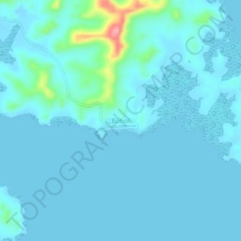
Name: Bohol topographic map, elevation, terrain.

Location: Bohol, Roxas, Palawan, Mimaropa, Philippines (10.46195 119.87220 10.50195 119.91220)

Average elevation: 12 m

Minimum elevation: -2 m

Maximum elevation: 128 m

Other topographic maps

Click on a map to view its topography, its elevation and its terrain.

Long Beach

Philippines > Palawan > Roxas > San Isidro

Average elevation: 4 m

Purao Island

Philippines > Palawan > Roxas

Average elevation: 0 m

Stanlake Island

Philippines > Palawan > Roxas

Average elevation: 0 m

Coconut Beach

Philippines > Palawan > Roxas

Average elevation: 23 m

Boayan

Philippines > Palawan > Roxas

Average elevation: 12 m

Gear up for your next adventure:

Camping Groundsheet - Protect your tent from moisture and dirt
🧤Insulated Winter Gloves - Heavy-duty protection for sub-zero Canadian adventures
🔥Emergency Fire Starter - Reliable ignition source for all weather conditions
💧Reusable Water Bottle - Durable water bottles for hydration on trails
Tent Footprint - Protect tent floor and increase durability

As an Amazon Associate, this site earns from qualifying purchases at no extra cost to you.