Geolocate

Coron topographic map

Click on the map to display elevation.

About this map

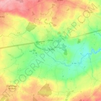
Name: Coron topographic map, elevation, terrain.

Location: Coron, Cholet, Maine-et-Loire, Pays de la Loire, Metropolitan France, 49690, France (47.08877 -0.68885 47.15139 -0.58748)

Average elevation: 152 m

Minimum elevation: 91 m

Maximum elevation: 216 m

Other topographic maps

Click on a map to view its topography, its elevation and its terrain.

Les Pentes

France > Pays de la Loire > Maine-et-Loire > Saumur

Average elevation: 49 m

Conception

France > Pays de la Loire > Maine-et-Loire

Average elevation: 72 m

Gallard

France > Pays de la Loire > Maine-et-Loire > Sèvremoine

Average elevation: 99 m

Gear up for your next adventure:

🕯️Camping Lantern - Illuminates your entire campsite with high-efficiency LEDs
🦌Outdoor Trail Camera - Monitor wildlife activity near your favorite spots
🧭GPS Tracker - Track your location in remote areas safely
🥾Approach Boots - Comfortable boots for hiking and climbing approaches
🥾Trail Hiking Socks - Comfortable socks to prevent blisters and fatigue

As an Amazon Associate, this site earns from qualifying purchases at no extra cost to you.