
Thank you for supporting this site ❤️
Make a donation
Make a donation
Gear up for your next adventure:
As an Amazon Associate, this site earns from qualifying purchases at no extra cost to you.
Penso topographic map
Click on the map to display elevation.
Thank you for supporting this site ❤️
Make a donation
Make a donation
Gear up for your next adventure:
As an Amazon Associate, this site earns from qualifying purchases at no extra cost to you.
About this map
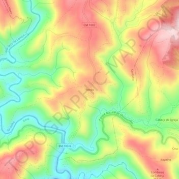
Name: Penso topographic map, elevation, terrain.
Location: Penso, Santalha, Vinhais, Bragance, 5320-193, Portugal (41.85757 -7.13195 41.89757 -7.09195)
Average elevation: 637 m
Minimum elevation: 460 m
Maximum elevation: 823 m
Thank you for supporting this site ❤️
Make a donation
Make a donation
Gear up for your next adventure:
As an Amazon Associate, this site earns from qualifying purchases at no extra cost to you.