
Thank you for supporting this site ❤️
Make a donation
Make a donation
Gear up for your next adventure:
As an Amazon Associate, this site earns from qualifying purchases at no extra cost to you.
Saldida topographic map
Click on the map to display elevation.
Thank you for supporting this site ❤️
Make a donation
Make a donation
Gear up for your next adventure:
As an Amazon Associate, this site earns from qualifying purchases at no extra cost to you.
About this map
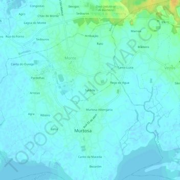
Name: Saldida topographic map, elevation, terrain.
Location: Saldida, Monte, Murtosa, Aveiro, 3870-137, Portugal (40.72581 -8.65635 40.76581 -8.61635)
Average elevation: 5 m
Minimum elevation: -2 m
Maximum elevation: 24 m
Thank you for supporting this site ❤️
Make a donation
Make a donation
Gear up for your next adventure:
As an Amazon Associate, this site earns from qualifying purchases at no extra cost to you.