Geolocate

Wayland topographic map

Click on the map to display elevation.

About this map

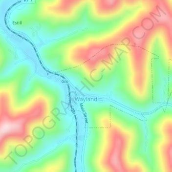
Name: Wayland topographic map, elevation, terrain.

Location: Wayland, Floyd County, Kentucky, United States (37.44057 -82.81145 37.45369 -82.78623)

Average elevation: 323 m

Minimum elevation: 207 m

Maximum elevation: 491 m

Other topographic maps

Click on a map to view its topography, its elevation and its terrain.

Langley

United States > Kentucky > Floyd County

Average elevation: 277 m

Eastern

United States > Kentucky > Floyd County

Average elevation: 274 m

Stanville

United States > Kentucky > Floyd County

Average elevation: 281 m

Northern

United States > Kentucky > Floyd County

Average elevation: 285 m

Northern

United States > Kentucky > Floyd County

Average elevation: 285 m

McDowell

United States > Kentucky > Floyd County

Average elevation: 324 m

Warco

United States > Kentucky > Floyd County

Average elevation: 269 m

Weeksbury

United States > Kentucky > Floyd County

Average elevation: 487 m

Eastern

United States > Kentucky > Floyd County

Average elevation: 274 m

Harold

United States > Kentucky > Floyd County

Average elevation: 268 m

Gear up for your next adventure:

👟Sport Hiking Sandals - Breathable footwear for water crossings and camp rest
🥾Trekking Boots - Durable boots for long-distance trekking
🪑Insulated Seat Pad - Protect your seat from cold rocks and wet logs
🧰Emergency Multi-Tool - Compact multi-tool for outdoor survival
🧤Rechargeable Heated Gloves - Extreme warmth for Canadian winter expeditions

As an Amazon Associate, this site earns from qualifying purchases at no extra cost to you.