Geolocate

Peridiello topographic map

Click on the map to display elevation.

About this map

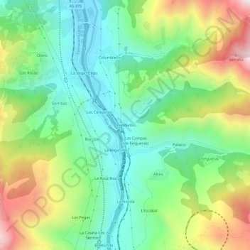
Name: Peridiello topographic map, elevation, terrain.

Location: Peridiello, Lena, Asturias, 33637, España (43.11109 -5.83527 43.15109 -5.79527)

Average elevation: 575 m

Minimum elevation: 310 m

Maximum elevation: 1,061 m

Other topographic maps

Click on a map to view its topography, its elevation and its terrain.

Río Huerna

España > Asturias > Lena

Average elevation: 1,041 m

Riospaso

España > Asturias > Lena

Average elevation: 1,115 m

Gear up for your next adventure:

🧢Hiking Sun Hat - Wide-brimmed protection for exposed mountain ridges
🥾Trail Hiking Boots - Supportive boots for rough trails
🥫Freeze-Dried Meals - Lightweight, high-calorie nutrition for multi-day treks
🎒Fully Waterproof Backpack - Total protection for photography gear and electronics
🛰️Satellite Messenger - Emergency communication for areas with no cell service

As an Amazon Associate, this site earns from qualifying purchases at no extra cost to you.