Geolocate

Walton topographic map

Click on the map to display elevation.

About this map

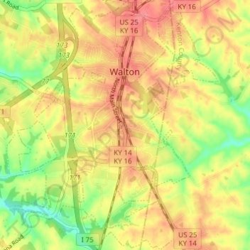
Name: Walton topographic map, elevation, terrain.

Location: Walton, Boone County, Kentucky, United States (38.84177 -84.64058 38.88927 -84.58744)

Average elevation: 264 m

Minimum elevation: 225 m

Maximum elevation: 292 m

Other topographic maps

Click on a map to view its topography, its elevation and its terrain.

Hamilton

United States > Kentucky > Boone County

Average elevation: 169 m

Hebron

United States > Kentucky > Boone County

Average elevation: 263 m

Verona

United States > Kentucky > Boone County

Average elevation: 259 m

Hebron

United States > Kentucky > Boone County

Average elevation: 263 m

Verona

United States > Kentucky > Boone County

Average elevation: 259 m

Gear up for your next adventure:

🧢Outdoor Cap - Protective cap for sun and rain during hikes
Camping Tent - Weather-resistant tents suitable for 2 to 6 people
❄️Traction Ice Cleats - Slip-on spikes for icy trails and winter hiking
🥾Trekking Boots - Durable boots for long-distance trekking
🧥Thermal Fleece Jacket - Versatile insulation for changing mountain temperatures

As an Amazon Associate, this site earns from qualifying purchases at no extra cost to you.