Geolocate

Parian topographic map

Click on the map to display elevation.

About this map

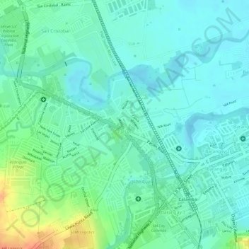
Name: Parian topographic map, elevation, terrain.

Location: Parian, Calamba, Laguna, Calabarzon, 4027, Philippines (14.20751 121.13778 14.22141 121.15857)

Average elevation: 21 m

Minimum elevation: 6 m

Maximum elevation: 56 m

Other topographic maps

Click on a map to view its topography, its elevation and its terrain.

Calamba Town Plaza

Philippines > Laguna > Calamba

Average elevation: 11 m

88 Spa & Resort

Philippines > Laguna > Calamba

Average elevation: 83 m

Bucal

Philippines > Laguna > Calamba

Average elevation: 22 m

Bucal Reservoir

Philippines > Laguna > Calamba

Average elevation: 42 m

ASN Ph2 Park

Philippines > Laguna > Calamba

Average elevation: 133 m

Gear up for your next adventure:

🧥Softshell Jacket - Windproof and breathable jacket for hiking
💡Portable Camping Lamp - Rechargeable lamp for campsite lighting
💡LED Camping Lantern - Illuminate your campsite with long-lasting lanterns
🏃Hydration Running Vest - Carry water and maps close to your body for speed
🥫Freeze-Dried Meals - Lightweight, high-calorie nutrition for multi-day treks

As an Amazon Associate, this site earns from qualifying purchases at no extra cost to you.