Geolocate

Pambujan topographic map

Click on the map to display elevation.

About this map

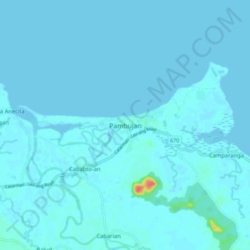
Name: Pambujan topographic map, elevation, terrain.

Location: Pambujan, Northern Samar, Eastern Visayas, 6413, Philippines (12.52396 124.88823 12.60396 124.96823)

Average elevation: 2 m

Minimum elevation: -2 m

Maximum elevation: 51 m

Other topographic maps

Click on a map to view its topography, its elevation and its terrain.

Catubig River

Philippines > Northern Samar

Average elevation: 38 m

Biri

Philippines > Northern Samar

Average elevation: 1 m

Catarman

Philippines > Northern Samar

Average elevation: 50 m

Sitio Rabbit

Philippines > Northern Samar > Victoria

Average elevation: 27 m

Tarnate

Philippines > Northern Samar > San Vicente

Average elevation: 27 m

Capul Island

Philippines > Northern Samar > Capul

Average elevation: 14 m

Palanit

Philippines > Northern Samar

Average elevation: 52 m

Capul

Philippines > Northern Samar

Average elevation: 5 m

Capul Island

Philippines > Northern Samar > Capul

Average elevation: 14 m

Catarman

Philippines > Northern Samar

Average elevation: 51 m

Catarman

Philippines > Northern Samar

Average elevation: 51 m

Gear up for your next adventure:

🔋Solar Power Bank - Keep your GPS and devices charged during long outdoor trips
🧢Hiking Hat - Sun-protective and breathable hats for long treks
🥾Approach Shoes - Shoes designed for climbing approaches and rugged trails
👟Leg Gaiters - Keep debris, mud, and snow out of your boots
🏃Hydration Running Vest - Carry water and maps close to your body for speed

As an Amazon Associate, this site earns from qualifying purchases at no extra cost to you.