Geolocate

Terre Haute topographic map

Click on the map to display elevation.

About this map

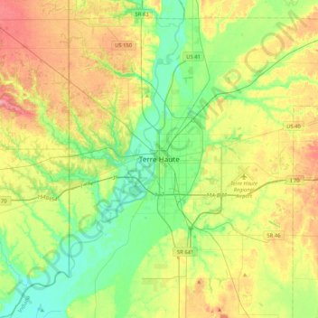
Name: Terre Haute topographic map, elevation, terrain.

Location: Terre Haute, Vigo County, Indiana, 47809, United States (39.30670 -87.57391 39.62670 -87.25391)

Average elevation: 169 m

Minimum elevation: 132 m

Maximum elevation: 227 m

Gear up for your next adventure:

🥾Hiking Leggings - Comfortable leggings for outdoor activities
🔥Camping Stove - Portable stoves to cook outdoors with ease
🐕Hiking Dog Pack - Let your canine companion carry their own water and food
🧴Sunscreen SPF - Broad-spectrum sunscreen for outdoor activities
🧴Outdoor Sunscreen - High SPF protection for high-altitude UV exposure

As an Amazon Associate, this site earns from qualifying purchases at no extra cost to you.