
Ava topographic map
Click on the map to display elevation.
About this map
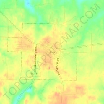
Name: Ava topographic map, elevation, terrain.
Location: Ava, Jackson County, Illinois, United States (37.88103 -89.50954 37.89586 -89.48654)
Average elevation: 177 m
Minimum elevation: 154 m
Maximum elevation: 190 m
Other topographic maps
Click on a map to view its topography, its elevation and its terrain.
Little Grand Canyon
United States > Illinois > Jackson County
Erosion carved this deep box canyon from the sandstone of the Shawnee Hills, opening into the floodplain of the Mississippi River near Turkey Bayou. The canyon contains several seasonal and a few permanent waterfalls, some descending through dramatic cascades of sculpted sandstone. The 3.6-mile (5.8 km) trail…
Average elevation: 168 m