Geolocate

Gavà topographic map

Click on the map to display elevation.

About this map

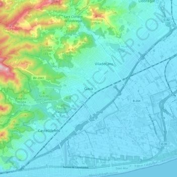
Name: Gavà topographic map, elevation, terrain.

Location: Gavà, Bajo Llobregat, Barcelona, Cataluña, 08850, España (41.26509 1.96631 41.34509 2.04631)

Average elevation: 61 m

Minimum elevation: -1 m

Maximum elevation: 392 m

Gear up for your next adventure:

👟Sport Hiking Sandals - Breathable footwear for water crossings and camp rest
🧢Sun Protection Cap - Breathable cap to protect from sun exposure
🧥Thermal Layer - Insulating layer for cold outdoor conditions
🕶️Polarized Sunglasses - Protect your eyes with durable polarized lenses
🧢Hiking Sun Hat - Wide-brimmed protection for exposed mountain ridges

As an Amazon Associate, this site earns from qualifying purchases at no extra cost to you.