Geolocate

Sector 6 topographic map

Click on the map to display elevation.

About this map

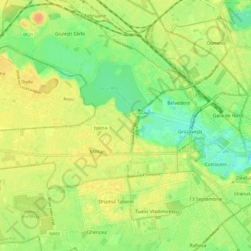
Name: Sector 6 topographic map, elevation, terrain.

Location: Sector 6, Bucharest, Romania (44.40612 25.96667 44.47968 26.07328)

Average elevation: 89 m

Minimum elevation: 71 m

Maximum elevation: 104 m

Other topographic maps

Click on a map to view its topography, its elevation and its terrain.

Parcul Circului

Romania > Bucharest

Average elevation: 85 m

Dealul Arsenalului

Romania > Bucharest

Average elevation: 84 m

Gear up for your next adventure:

🧭GPS Tracker - Track your location in remote areas safely
🔦UV Flashlight - Detect minerals or specific insects in the dark
🔋Emergency Crank Radio - Weather alerts and power without needing batteries
🧳Compression Sacks - Maximize space in your backpack by shrinking gear
🪑Insulated Seat Pad - Protect your seat from cold rocks and wet logs

As an Amazon Associate, this site earns from qualifying purchases at no extra cost to you.