
Gotegaon Tahsil topographic map
Interactive map
Click on the map to display elevation.
About this map
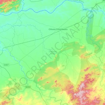
Name: Gotegaon Tahsil topographic map, elevation, terrain.
Location: Gotegaon Tahsil, Narsimhapur, Madhya Pradesh, India (22.77854 79.30295 23.14315 79.64208)
Average elevation: 402 m
Minimum elevation: 326 m
Maximum elevation: 637 m
Other topographic maps
Click on a map to view its topography, its elevation and its terrain.
Sher
India > Madhya Pradesh > Gotegaon Tahsil
Sher, Gotegaon Tahsil, Narsinghpur District, Madhya Pradesh, India
Average elevation: 468 m