
Thank you for supporting this site ❤️
Make a donation
Make a donation
Gear up for your next adventure:
As an Amazon Associate, this site earns from qualifying purchases at no extra cost to you.
Chhati topographic map
Click on the map to display elevation.
Thank you for supporting this site ❤️
Make a donation
Make a donation
Gear up for your next adventure:
As an Amazon Associate, this site earns from qualifying purchases at no extra cost to you.
About this map
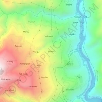
Name: Chhati topographic map, elevation, terrain.
Location: Chhati, Nakot, Tehri, Tehri Garhwal, Uttarakhand, India (30.29614 78.45448 30.33614 78.49448)
Average elevation: 1,043 m
Minimum elevation: 566 m
Maximum elevation: 1,740 m
Thank you for supporting this site ❤️
Make a donation
Make a donation
Gear up for your next adventure:
As an Amazon Associate, this site earns from qualifying purchases at no extra cost to you.