Geolocate

Mentor topographic map

Click on the map to display elevation.

About this map

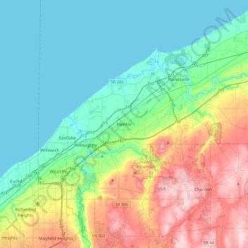
Name: Mentor topographic map, elevation, terrain.

Location: Mentor, Lake County, Ohio, 44060, United States (41.50648 -81.49998 41.82648 -81.17998)

Average elevation: 242 m

Minimum elevation: 172 m

Maximum elevation: 416 m

Gear up for your next adventure:

🔦UV Flashlight - Detect minerals or specific insects in the dark
🪑Insulated Seat Pad - Protect your seat from cold rocks and wet logs
🧴Sunscreen SPF - Broad-spectrum sunscreen for outdoor activities
🧳Compression Sacks - Maximize space in your backpack by shrinking gear
💡Portable Camping Lamp - Rechargeable lamp for campsite lighting

As an Amazon Associate, this site earns from qualifying purchases at no extra cost to you.