
Make a donation
Gear up for your next adventure:
As an Amazon Associate, this site earns from qualifying purchases at no extra cost to you.
Taḥanut topographic map
Click on the map to display elevation.
Make a donation
Gear up for your next adventure:
As an Amazon Associate, this site earns from qualifying purchases at no extra cost to you.
About this map
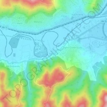
Name: Taḥanut topographic map, elevation, terrain.
Location: Taḥanut, Tala Hamza, Daïra Tichy, Béjaïa, 06120, Algérie (36.68060 5.01036 36.72060 5.05036)
Average elevation: 103 m
Minimum elevation: 0 m
Maximum elevation: 392 m
Make a donation
Gear up for your next adventure:
As an Amazon Associate, this site earns from qualifying purchases at no extra cost to you.
Other topographic maps
Click on a map to view its topography, its elevation and its terrain.
Tichy
Algérie > Béjaïa > Daïra Tichy
Le territoire de la tribu des Aït Amrous qui s'étend du Nord au Sud depuis la Méditerranée jusqu'à l'oued Djamaâ et de l'Ouest à l'Est depuis le territoire des Aït Vimoune jusqu'à celui des Aït Ouaret Ou-Ali a une superficie de 2268 ha 16 ares. Au point de vue topographique, cette superficie se…
Average elevation: 412 m