Geolocate

Derio topographic map

Click on the map to display elevation.

About this map

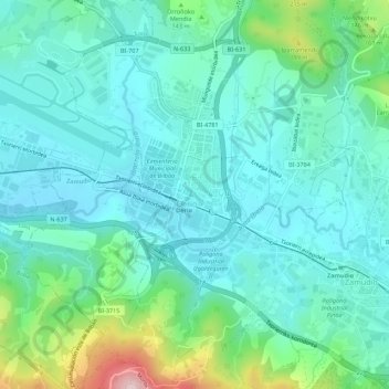
Name: Derio topographic map, elevation, terrain.

Location: Derio, Vizcaya, País Vasco, 48160, España (43.27169 -2.90588 43.31169 -2.86588)

Average elevation: 77 m

Minimum elevation: 10 m

Maximum elevation: 335 m

Gear up for your next adventure:

Backpacking Tent - Lightweight tent for long-distance hiking trips
🔦LED Headlamp - Hands-free lighting for early morning starts or late finishes
🥾Mountain Trail Shoes - High-traction shoes for mountain trails
🧥Thermal Fleece Jacket - Versatile insulation for changing mountain temperatures
🏕️Camping Hammock - Integrated protection for sleeping between trees

As an Amazon Associate, this site earns from qualifying purchases at no extra cost to you.