
Make a donation
Gear up for your next adventure:
As an Amazon Associate, this site earns from qualifying purchases at no extra cost to you.
Großaga topographic map
Click on the map to display elevation.
Make a donation
Gear up for your next adventure:
As an Amazon Associate, this site earns from qualifying purchases at no extra cost to you.
Großaga
Die schon 1872 bestehende Schützengesellschaft erfuhr 1997 eine Neugründung als Schützengesellschaft Großaga e. V.; jährliche Schützenfeste knüpfen wieder an die alte Tradition an. Seit 1951 gibt es eine Schalmeienkapelle, die weithin bekannt ist. Traditioneller Höhepunkt des Jahres ist das Maibaumsetzen. Seit 1880 besteht zudem ein Rassegeflügelzuchtverein, seit 1998 der Heimatverein Aga e. V.
Make a donation
Gear up for your next adventure:
As an Amazon Associate, this site earns from qualifying purchases at no extra cost to you.
About this map
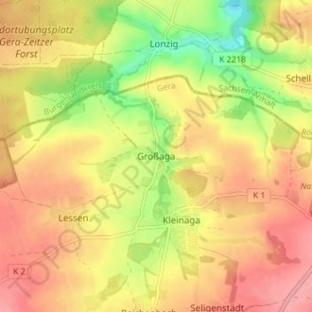
Name: Großaga topographic map, elevation, terrain.
Location: Großaga, Gera, Thüringen, Deutschland (50.94631 12.06620 50.98631 12.10620)
Average elevation: 276 m
Minimum elevation: 219 m
Maximum elevation: 316 m
Make a donation
Gear up for your next adventure:
As an Amazon Associate, this site earns from qualifying purchases at no extra cost to you.
Other topographic maps
Click on a map to view its topography, its elevation and its terrain.
Ferberturm
Deutschland > Thüringen > Gera
Der Ferberturm ist ein 21 Meter hoher Aussichtsturm auf der Ronneburger Höhe in der thüringischen Stadt Gera.
Average elevation: 248 m