
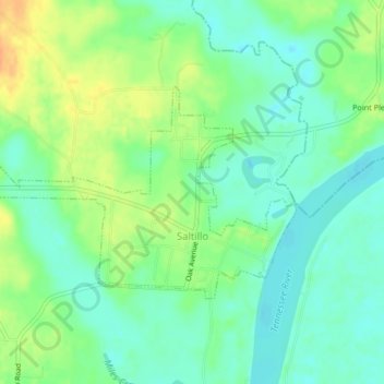
Saltillo topographic map
Interactive map
Click on the map to display elevation.
About this map
Name: Saltillo topographic map, elevation, terrain.
Average elevation: 122 m
Minimum elevation: 108 m
Maximum elevation: 144 m
Other topographic maps
Click on a map to view its topography, its elevation and its terrain.
Shiloh
United States > Tennessee > Hardin County
Shiloh, Hardin County, West Tennessee, Tennessee, 38376, United States
Average elevation: 148 m
Crossroads
United States > Tennessee > Hardin County
Crossroads, Hardin County, West Tennessee, Tennessee, United States
Average elevation: 146 m
Counce
United States > Tennessee > Hardin County
Counce, Hardin County, West Tennessee, Tennessee, 38326, United States
Average elevation: 137 m
Savannah
United States > Tennessee > Hardin County
Savannah, Hardin County, West Tennessee, Tennessee, United States
Average elevation: 126 m
Southside
United States > Tennessee > Hardin County > Southside
Southside, Hardin County, Tennessee, 38326:38376, United States
Average elevation: 160 m