Geolocate

Morai topographic map

Click on the map to display elevation.

About this map

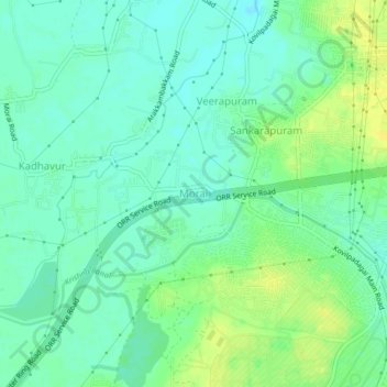
Name: Morai topographic map, elevation, terrain.

Location: Morai, Ambattur, Thiruvallur, Tamil Nadu, 600055, India (13.15682 80.05897 13.19682 80.09897)

Average elevation: 27 m

Minimum elevation: 19 m

Maximum elevation: 39 m

Other topographic maps

Click on a map to view its topography, its elevation and its terrain.

Porur Lake

India > Tamil Nadu > Ambattur

Average elevation: 17 m

Ayapakkam Lake

India > Tamil Nadu > Ambattur > Kolladi

Average elevation: 19 m

Zone 7 Ambattur

India > Tamil Nadu > Ambattur > Chennai

Average elevation: 18 m

Ward 83

India > Tamil Nadu > Ambattur

Average elevation: 13 m

Zone 7 Ambattur

India > Tamil Nadu > Ambattur

Average elevation: 18 m

Zone 7 Ambattur

India > Tamil Nadu > Ambattur > Chennai

Average elevation: 18 m

Zone 7 Ambattur

India > Tamil Nadu > Ambattur

Average elevation: 18 m

Chennai metropolitan area

India > Tamil Nadu > Ambattur

Average elevation: 18 m

Zone 11 Valasaravakkam

India > Tamil Nadu > Ambattur

Average elevation: 15 m

Zone 7 Ambattur

India > Tamil Nadu > Ambattur

Average elevation: 18 m

Gear up for your next adventure:

🌬️Windproof Camp Stove - Efficient cooking even on exposed mountain peaks
💧Collapsible Water Bottle - Space-saving water bottle for outdoor activities
🦌Outdoor Trail Camera - Monitor wildlife activity near your favorite spots
🥾Approach Shoes - Shoes designed for climbing approaches and rugged trails
🧴Insect Repellent - Protect yourself from bugs during outdoor adventures

As an Amazon Associate, this site earns from qualifying purchases at no extra cost to you.