
Make a donation
Gear up for your next adventure:
As an Amazon Associate, this site earns from qualifying purchases at no extra cost to you.
Furgler topographic map
Click on the map to display elevation.
Make a donation
Gear up for your next adventure:
As an Amazon Associate, this site earns from qualifying purchases at no extra cost to you.
Furgler
Auf einer weiteren Gedenktafel erinnern die Kameraden von der Bergrettung Serfaus und seine Familie an Siegmund Oberacher (* 16. November 1944, † 23. März 1997): „Wenn Du erschöpft bist, suche neue Kräfte in den Höhen der Berge, wo Du Gott und dir selber am nächsten sein kannst. Je höher man steigt, umso klarer wird das Wasser, umso reiner der Schnee, umso leuchtender das Himmelszelt. Ein jeder Tag ist wie ein kleines Jahr und jede Stunde Bergeinsamkeit ist Ewigkeit.“
Make a donation
Gear up for your next adventure:
As an Amazon Associate, this site earns from qualifying purchases at no extra cost to you.
About this map
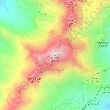
Name: Furgler topographic map, elevation, terrain.
Location: Furgler, Serfaus, Bezirk Landeck, Tirol, Österreich (47.04028 10.51181 47.04038 10.51191)
Average elevation: 2,565 m
Minimum elevation: 2,171 m
Maximum elevation: 2,986 m
Make a donation
Gear up for your next adventure:
As an Amazon Associate, this site earns from qualifying purchases at no extra cost to you.