Geolocate

Harbledown topographic map

Click on the map to display elevation.

About this map

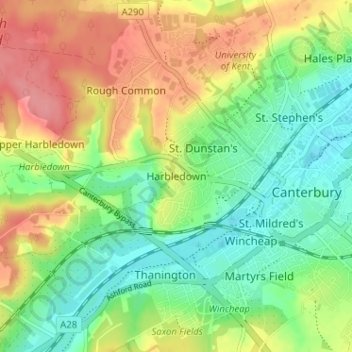
Name: Harbledown topographic map, elevation, terrain.

Location: Harbledown, Canterbury, Kent, England, CT2 8NW, United Kingdom (51.26183 1.03658 51.30183 1.07658)

Average elevation: 41 m

Minimum elevation: 6 m

Maximum elevation: 87 m

Other topographic maps

Click on a map to view its topography, its elevation and its terrain.

Littlebourne

United Kingdom > England > Kent > Canterbury

Average elevation: 21 m

Gear up for your next adventure:

🧦Crew Hiking Socks - Comfortable socks for long-distance hikes
🥫Freeze-Dried Meals - Lightweight, high-calorie nutrition for multi-day treks
🧥Packable Rain Jacket - Breathable waterproof layer for unpredictable weather
🍽️Titanium Camping Spork - Ultralight and indestructible eating utensil
🛶Waterproof Dry Bags - Keep electronics and clothes dry during river crossings

As an Amazon Associate, this site earns from qualifying purchases at no extra cost to you.