
Thank you for supporting this site ❤️
Make a donation
Make a donation
Gear up for your next adventure:
As an Amazon Associate, this site earns from qualifying purchases at no extra cost to you.
Wallmoden topographic map
Click on the map to display elevation.
Thank you for supporting this site ❤️
Make a donation
Make a donation
Gear up for your next adventure:
As an Amazon Associate, this site earns from qualifying purchases at no extra cost to you.
About this map
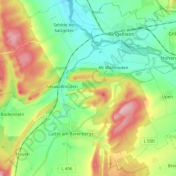
Name: Wallmoden topographic map, elevation, terrain.
Average elevation: 183 m
Minimum elevation: 116 m
Maximum elevation: 307 m
Thank you for supporting this site ❤️
Make a donation
Make a donation
Gear up for your next adventure:
As an Amazon Associate, this site earns from qualifying purchases at no extra cost to you.
Other topographic maps
Click on a map to view its topography, its elevation and its terrain.
Ostlutter
Deutschland > Niedersachsen > Landkreis Goslar > Langelsheim
Der Ort liegt am südwestlichen Ende des bewaldeten Höhenzugs Wahrenberg, einem Teil des Innersteberglands.
Average elevation: 210 m