
Make a donation
Gear up for your next adventure:
As an Amazon Associate, this site earns from qualifying purchases at no extra cost to you.
Astfeld topographic map
Click on the map to display elevation.
Make a donation
Gear up for your next adventure:
As an Amazon Associate, this site earns from qualifying purchases at no extra cost to you.
Astfeld
Astfeld (italienisch Campolasta) ist eine Ortschaft in der Gemeinde Sarntal in Südtirol. Sie befindet sich auf etwa 1020 m Höhe an jener Stelle, wo das Durnholzer Tal vom Sarntal Richtung Nordosten abzweigt. Dementsprechend liegt Astfeld auch an der Einmündung des Durnholzer Bachs in die Talfer. Die nächstgelegenen Siedlungen sind talabwärts in dichter Folge das nahezu mit Astfeld zusammengewachsene Nordheim (die beiden Ortschaften, die zusammen rund 1000 Einwohner haben, werden gelegentlich auch zu Nordheim-Astfeld vermengt) und der Hauptort Sarnthein. Der von Astfeld talaufwärts folgende Abschnitt des Sarntals, ab hier auch Penser Tal genannt, ist wesentlich dünner besiedelt.
Make a donation
Gear up for your next adventure:
As an Amazon Associate, this site earns from qualifying purchases at no extra cost to you.
About this map
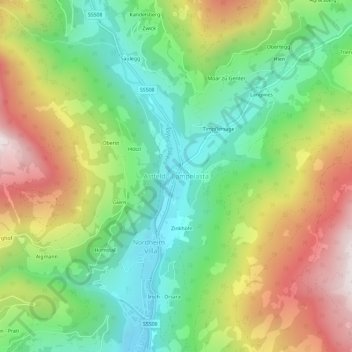
Name: Astfeld topographic map, elevation, terrain.
Average elevation: 1,356 m
Minimum elevation: 972 m
Maximum elevation: 1,924 m
Make a donation
Gear up for your next adventure:
As an Amazon Associate, this site earns from qualifying purchases at no extra cost to you.