Geolocate

Manlapay topographic map

Click on the map to display elevation.

About this map

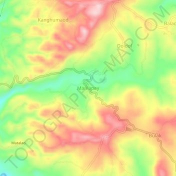
Name: Manlapay topographic map, elevation, terrain.

Location: Manlapay, Dumanjug, Cebu, Central Visayas, 6035, Philippines (10.03127 123.47313 10.07127 123.51313)

Average elevation: 154 m

Minimum elevation: 32 m

Maximum elevation: 259 m

Other topographic maps

Click on a map to view its topography, its elevation and its terrain.

Putaw River

Philippines > Cebu > Dumanjug

Average elevation: 49 m

Putaw River

Philippines > Cebu > Dumanjug

Average elevation: 49 m

Gear up for your next adventure:

Camping Tent - Weather-resistant tents suitable for 2 to 6 people
🩹Compact First Aid Kit - Pre-packed essentials for common trail injuries
🧢Outdoor Cap - Protective cap for sun and rain during hikes
🧥Waterproof Hiking Jacket - Protect yourself from rain and wind while hiking
🧥Thermal Layer - Insulating layer for cold outdoor conditions

As an Amazon Associate, this site earns from qualifying purchases at no extra cost to you.