Geolocate

Bilandu topographic map

Click on the map to display elevation.

About this map

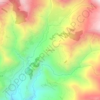
Name: Bilandu topographic map, elevation, terrain.

Location: Bilandu, Champadevi, Okhaldhunga, Koshi Province, Nepal (27.32360 86.29372 27.36360 86.33372)

Average elevation: 1,613 m

Minimum elevation: 1,036 m

Maximum elevation: 2,268 m

Other topographic maps

Click on a map to view its topography, its elevation and its terrain.

Siddhicharan

Nepal > Koshi Province > Okhaldhunga

Average elevation: 1,659 m

Manebhanjyang

Nepal > Koshi Province > Okhaldhunga

Average elevation: 1,066 m

Manebhanjyang

Nepal > Koshi Province > Okhaldhunga

Average elevation: 1,066 m

Gear up for your next adventure:

🧢Outdoor Visor - Breathable visor for sunny hikes
🧥Waterproof Hiking Jacket - Protect yourself from rain and wind while hiking
🧊Portable Cooler - Keep food and drinks cold during outdoor adventures
💧Hydration Pack - Hands-free hydration system for long hikes
🌡️Emergency Mylar Blankets - Compact thermal protection for unexpected nights outdoors

As an Amazon Associate, this site earns from qualifying purchases at no extra cost to you.