Geolocate

Banbury topographic map

Interactive map

Click on the map to display elevation.

About this map

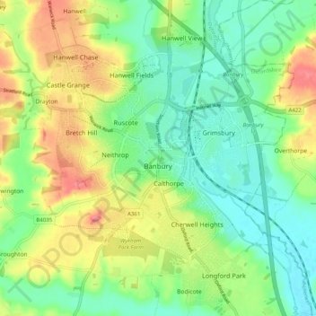
Name: Banbury topographic map, elevation, terrain.

Location: Banbury, Cherwell District, Oxfordshire, England, United Kingdom (52.03125 -1.37550 52.09226 -1.29637)

Average elevation: 116 m

Minimum elevation: 84 m

Maximum elevation: 168 m

Other topographic maps

Click on a map to view its topography, its elevation and its terrain.

Hornton

United Kingdom > England > Oxfordshire > Cherwell District

Hornton, Cherwell District, Oxfordshire, England, United Kingdom

Average elevation: 172 m

Juniper Hill

United Kingdom > England > Oxfordshire > Cherwell District > Cottisford

Juniper Hill, Cottisford, Cherwell District, Oxfordshire, England, NN13 5RN, United Kingdom

Average elevation: 126 m

Bletchingdon

United Kingdom > England > Oxfordshire > Cherwell District

Bletchingdon, Cherwell District, Oxfordshire, England, United Kingdom

Average elevation: 76 m

Bicester

United Kingdom > England > Oxfordshire > Cherwell District

Bicester, Cherwell District, Oxfordshire, England, United Kingdom

Average elevation: 76 m

Duns Tew

United Kingdom > England > Oxfordshire > Cherwell District

Duns Tew, Cherwell District, Oxfordshire, England, United Kingdom

Average elevation: 125 m