
Thank you for supporting this site ❤️
Make a donation
Make a donation
Gear up for your next adventure:
As an Amazon Associate, this site earns from qualifying purchases at no extra cost to you.
Sellnrod topographic map
Click on the map to display elevation.
Thank you for supporting this site ❤️
Make a donation
Make a donation
Gear up for your next adventure:
As an Amazon Associate, this site earns from qualifying purchases at no extra cost to you.
Sellnrod
Die Statistisch-topographisch-historische Beschreibung des Großherzogthums Hessen berichtet 1830 über Sellnrod.
Thank you for supporting this site ❤️
Make a donation
Make a donation
Gear up for your next adventure:
As an Amazon Associate, this site earns from qualifying purchases at no extra cost to you.
About this map
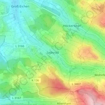
Name: Sellnrod topographic map, elevation, terrain.
Location: Sellnrod, Mücke, Vogelsbergkreis, Hessen, Deutschland (50.56153 9.07538 50.60153 9.11538)
Average elevation: 358 m
Minimum elevation: 282 m
Maximum elevation: 503 m
Thank you for supporting this site ❤️
Make a donation
Make a donation
Gear up for your next adventure:
As an Amazon Associate, this site earns from qualifying purchases at no extra cost to you.